How To Get a Copy of a Title Plan
At Property Documents Ltd we provide official HM Land Registry title plans. If you don’t have a copy of your title register we recommend purchasing one. We offer a bundle pack so you can order your title register and title plan at a discounted price.
What is a Title Plan?
A title plan is a detailed map that visually represents the information found in a property’s title register. It shows land, property, boundaries, easements, covenants, rights of access, and other features. A title plan is required if you’re selling or buying a property, or dealing with a land dispute with a neighbour.
A title plan may also be known as:
- Filed Plan
- Land Registry Plan
- Title Map
- Land Ownership Map
- Property Boundary Map
- Registered Title Plan
- Land Title Diagram
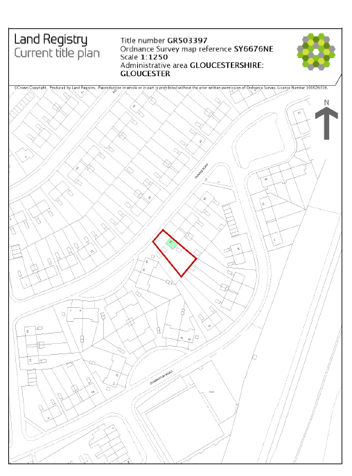
Land Registry Title Plan (PDF Sample): Click here to view PDF sample
What a Title Plan Shows: Land Boundaries, Access Rights & More
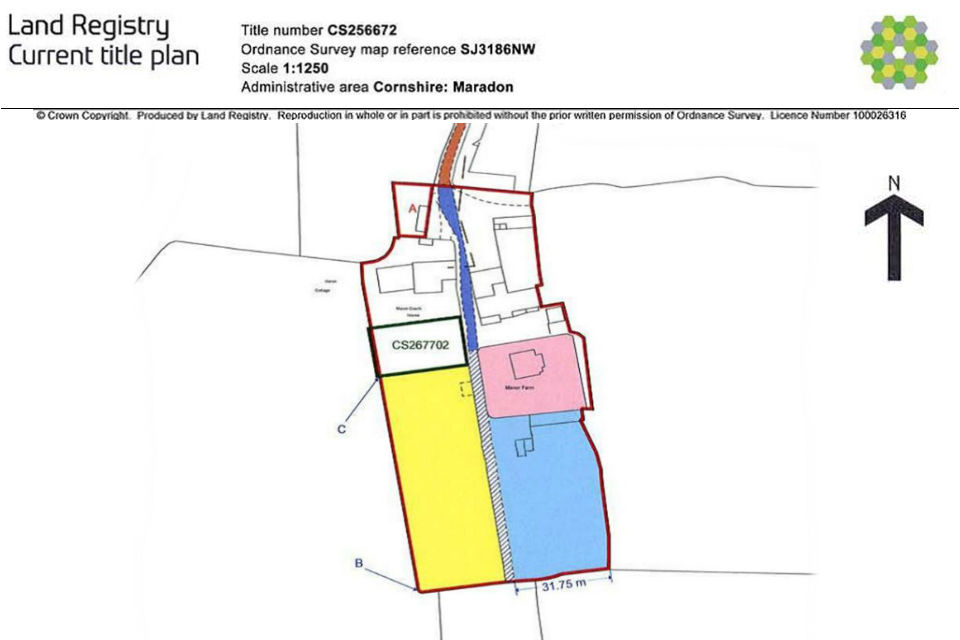
- Title Number: A unique reference number used to identify property or land.
- OS Map Grid Square Reference: A reference number used to locate the area from the Ordnance Survey Map.
- North Reference: A compass showing the map orientation in relation to north.
- Extent Line: A red line that outlines the general boundaries of land.
- Various Lines, Colours, and Markings: Used to indicate various features such as boundaries, rights of way, access areas, and other physical or legal features.
- Map Scale: The scale of the map (commonly 1:1250 scale)
- Administrative Area: The local authority in which the property is registered.
Ordnance Survey Map
A title plan contains a map tile from the Ordnance Survey. The map shows the registered property and/or land including any features. These are represented as various lines and colours.
Colours and Markings on Land Registry Title Plan Map
A title plan contains various markings and colours that have a specific meaning.
The image below is taken from the official HM Land Registry documents that shows what each of the colours and markings mean.
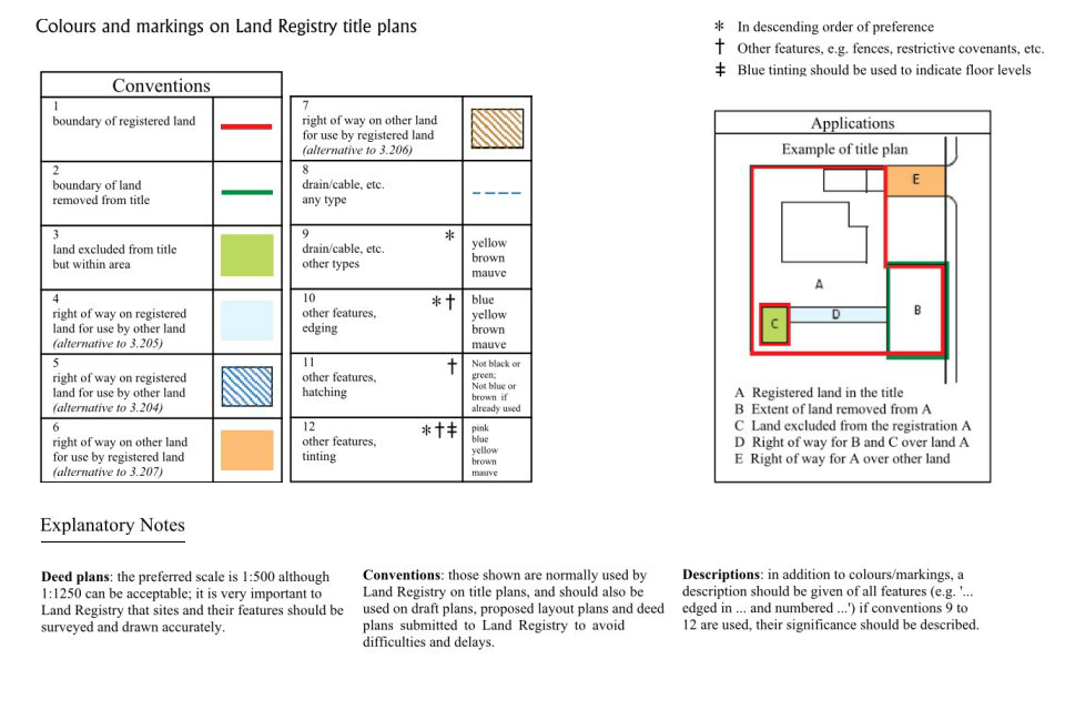
The image is helpful, but lacks clarity. The table below provides more information on what the colours and markings mean.
| Colour | Marking | Description |
|---|---|---|
| Red | Line | Marks the general boundaries of the property or land. The official name for this line is called the “extent”. |
| Green | Line | Used to mark land boundaries removed from the title. |
| Green | Shading | Shaded blocks show land excluded from the title, but within the mapped area. |
| Light Blue | Shading | Shaded blocks show rights of way on registered land that is for use by other land. |
| Blue | Hatching | Hatched blocks show rights of way on registered land for others to use such as: easements or access rights. |
| Orange | Shading | Shaded blocks are used to mark rights of way or shared access areas. |
| Brown | Hatching | Also used to mark rights of way or shared access areas. |
| Black | Dashed Line | Used to show drains, pipes, cables, or underground features. |
| Yellow, Brown, Mauve | Line/Shading | Generally used to show drains, cables, or other sub-surface/service-related features. |
| Blue, Yellow, Brown, Mauve | Line/Edging | Used to mark other features, edges, or shared boundaries. |
| Any colour not black or green (or not blue/brown if used) | Hatching | Used to mark other features, especially for distinctions or overlays in complex titles. |
| Pink, Blue, Yellow, Brown, Mauve | Tinting (Block) | Used to tint areas on the map showing complex interests, multiple ownerships, or exceptions. |
Map Scale
Depending on the type of land or property the scale of the map included in a title plan can be one of the three sizes:
– 1:1250 scale (1cm = 12.5m) for land in urban areas
– 1:2500 scale (1cm = 25m) for land in rural areas
– 1:10 000 scale (1cm = 100m) scale for land in mountain and moorland area
Property Boundaries
There’s two types of property boundaries: general boundaries and legal boundaries. Understanding the difference between them is important.
General Boundary
A general boundary is shown as a red line (the extent line) on a title plan. It gives an approximate indication of the land included in the title. It is not a legal boundary and cannot be used to determine ownership in a land dispute.
Physical features are often used to represent general boundaries:
- Hedges
- Fences
- Tree lines
- Ditches
- Rivers or streams
- Lakes
- Roadways
- Pathways
Legal Boundary
A legal boundary is an invisible line that separates the ownership of land between two or more properties. A title plan does not show the legal boundary. Only a court, or the Land Registration division of the Property Chamber, can determine the exact position of a property boundary.
T Marks and Boundary Ownership
A T mark is used to show the ownership of a general boundary. The owner of the land where the upright T is positioned has the liability to maintain and repair it.
A title register is required to describe the boundaries marked with a T. If the title registry contains no information about the boundaries marked with T on the title plan, then the T marks mean nothing in law and will be ignored.
Why Do I Need a Title Plan?
- If you’re planning on buying, selling, or redeveloping your property a title plan will be required.
- If you have any land disputes with a neighbour a title deed can help visualise land boundaries in order to help resolve any dispute.
- If you’re building or extending your property the local council will require a copy of your title plan before approving any project.
- Solicitors or conveyancing will need your title plan if you’re going through the conveyancing process.
- If you’ve lost your original title plan you’ll need to order a replacement. It’s always a good idea to have a copy of your documents to hand. You never know when you might need them.
FAQ
Who Are The Ordnance Survey?
Ordnance Survey is an agency responsible for mapping Great Britain. They produce and maintain up-to-date maps of every square inch of the nation. Their maps are used to reference property, land, and its boundaries for Land Registry title plans.
What’s the Difference Between a Title Plan and a Title Register
A title plan is a visual representation of property and land. It shows general boundaries, and physical features of a title.
A title register is a written document that contains information about the property owner, mortgages and charges, restrictions, and boundary responsibility/ownership.
Can a Title Plan be used in Court?
No. A title plan does not show any legal boundaries. It only shows an approximate boundary (the red extent line). If you’re going through a land dispute (for example a dispute over a boundary fence) you should seek legal advice from a solicitor.
Reviews
There are no reviews yet.